Check out
Michael's
Gila Nature Blog
Casitas de Gila Guesthouses is the BEST lodging in Silver City for Birding Enthusiasts!
Read Why Here!
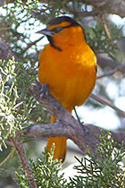
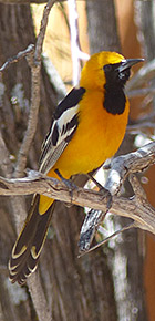
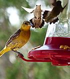
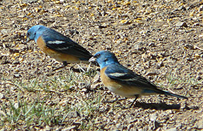
Bullock's Oriole
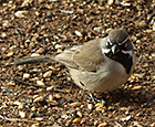
Black-throated Sparrow
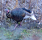
Wild Turkey
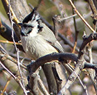
Bridled Titmouse
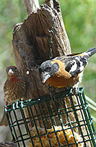
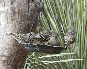
Black-headed Grosbeak & House Finch
Hooded Oriole
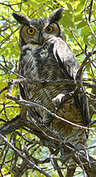
Great Horned Owl
Sharing the spoils!

Bewick's Wren
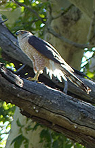
Cooper's Hawk
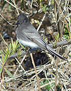
Black Phoebe
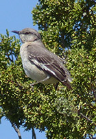
Mockingbird
|
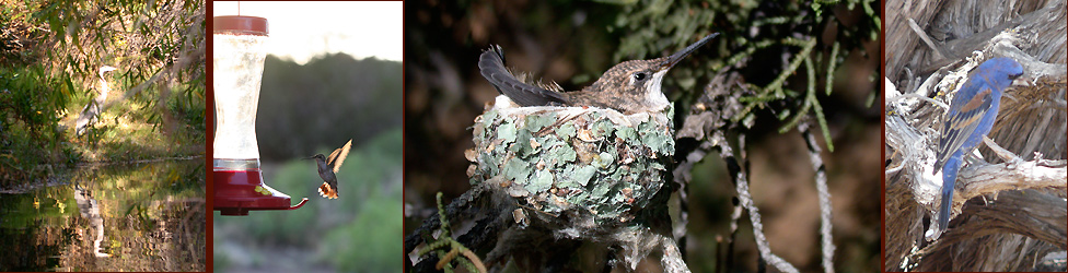
Birds Seen or Heard Along Bear Creek
at Casitas de Gila Guesthouses
…
 Grant County and the Silver City area, where Casitas de Gila Guesthouses is located, is recognized as one of the finest birding areas in Southwest New Mexico, having 355 reported species or roughly 65% of the 544 species found throughout New Mexico. Since 1999, Casitas de Gila Guesthouses and Bear Creek Nature Preserve, located in the northern part of Grant County about 25 miles northwest of Silver City, have been offering visiting bird enthusiasts some of the best New Mexico birding, with a current count of 147 species found on our property. Grant County and the Silver City area, where Casitas de Gila Guesthouses is located, is recognized as one of the finest birding areas in Southwest New Mexico, having 355 reported species or roughly 65% of the 544 species found throughout New Mexico. Since 1999, Casitas de Gila Guesthouses and Bear Creek Nature Preserve, located in the northern part of Grant County about 25 miles northwest of Silver City, have been offering visiting bird enthusiasts some of the best New Mexico birding, with a current count of 147 species found on our property.
The large diversity of bird species at the Casitas is due to the presence of 4 out of the 10 different bird habitats (.pdf file) recognized in our area:
- Bear Creek Deciduous Riparian Habitat
- High Chihuahuan Desert Habitat
- Juniper and Oak Habitat
- Mountain Grassland Habitat
Each of these four habitats are easily accessed by guests staying at Casitas de Gila. Our property has 15 mapped, marked, and maintained trails, providing 7 miles of birding, hiking, and connection to Nature on the 265 acres of Casitas land, including ¾ mile of Bear Creek.
 Just five miles to the north of Casitas de Gila Guesthouses is the Upper Box of the Gila River, a spectacular landscape where the Gila River emerges from the deep canyons of the towering Mogollon Mountains and the Pinos Altos Range in the Gila National Forest. The Gila National Forest, comprising 3.3 million acres, is one of the most remote, pristine, and least developed National Forests in the Southwest. The Gila National Forest is best known for its several wilderness areas, in particular the Gila Wilderness, the first designated wilderness area in the United States. This magnificent landscape, with its cool summer temperatures, and relatively warm winters, support a unique combination of birds, plants, and animals that share this diverse ecosystem, where the Rocky Mountains meet the High Chihuahuan Desert. Just five miles to the north of Casitas de Gila Guesthouses is the Upper Box of the Gila River, a spectacular landscape where the Gila River emerges from the deep canyons of the towering Mogollon Mountains and the Pinos Altos Range in the Gila National Forest. The Gila National Forest, comprising 3.3 million acres, is one of the most remote, pristine, and least developed National Forests in the Southwest. The Gila National Forest is best known for its several wilderness areas, in particular the Gila Wilderness, the first designated wilderness area in the United States. This magnificent landscape, with its cool summer temperatures, and relatively warm winters, support a unique combination of birds, plants, and animals that share this diverse ecosystem, where the Rocky Mountains meet the High Chihuahuan Desert.
Flowing out of the narrow canyon confines of the Upper Box, the Gila River widens out into a wide floodplain bordered by a mature riverine forest of cottonwood, sycamore, and willow. From this point, the Gila River then winds its way southwest for about 16 miles through the many thousands of acres of ranch and farm lands that comprise the broad Gila Valley, passing between the small communities of Cliff and Gila at about the halfway point, before continuing on to reenter the Gila National Forest once again in the Burro Mountains. Situated at intervals along this 16-mile course are 7 remarkable designated birding sites that are located on Gila National Forest, New Mexico Game and Fish, and The Nature Conservancy lands, that are open year-round to the public for birding activities. When considered as a whole, this 16-mile natural corridor offers an incredibly rich diversity of protected public land and diverse habitat and bird species, with over 200 reported species that reside year round or visit the area over the coarse of a year. Guests at Casitas de Gila Guesthouses will appreciate that all 7 of these dedicated birding localities lie within a half-hour drive from the Casitas. Each can be easily accessed using the maps, checklists, and relevant local birding information that we are delighted to make available to our guests.
Read our Birding Page to learn more about why Casitas de Gila has some of the best New Mexico birding in the Silver City area.
Call us to book your stay Casitas de Gila Guesthouses
and start mapping out your path to New Mexico birding paradise!
Birds Seen or Heard at the Bear CreekNature Preserve include:
| |
Waterfowl
Mallard/Mexican Duck
Grouse, Quail, and Allies
Scaled Quail
Gambel's Quail
Montezuma Quail
Wild Turkey
Pidgeons & Doves
Eurasian Collared-Dove
White-winged Dove
Mourning Dove
Band-tailed Pidgeon
Cuckoos
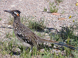
Greater Roadrunner
Yellow-billed Cuckoo
Nightjars
Common Nighthawk
Common Poorwill
Swifts
White-throated Swift
Hummingbirds
Black-chinned Hummingbird
Broad-tailed Hummingbird
Rufous Hummingbird
Calliope Hummingbird
Magnificent Hummingbird
Cranes
Sandhill Crane
Shorebirds
Killdeer
Wilson's Snipe
Herons, Ibis, & Allies
Great Blue Heron
Vultures, Hawks, & Allies
Turkey Vulture
Golden Eagle
Northern Harrier
Northern Goshawk
Sharp-shinned Hawk
Cooper's Hawk
Common Black Hawk
Swainson's Hawk
Zone-tailed Hawk
Red-tailed Hawk
Owls
Great Horned Owl
Western Screech Owl
Elf Owl
Pine Siskins
Kingfishers
Belted Kingfisher
Woodpeckers
Red-naped Sapsucker
Williamson's Sapsucker
Acorn Woodpecker
Gila Woodpecker
Ladder-backed Woodpecker
Hairy Woodpecker
Northern Flicker
Downy Woodpecker
Falcons & Caracaras
American Kestrel
Merlin
Peregrine Falcon
Tyrant Flycatchers:
Pewees, Kingbirds, & Allies
Olive-sided Flycatcher
Western Wood-Pewee
Hammond's Flycatcher
Dusky Flycatcher
Cordilleran Flycatcher
Black Phoebe
Say's Phoebe
Ash-throated Flycatcher
Brown-crested Flycatcher
Cassin's Kingbird
Western Kingbird
Shrikes
Loggerhead Shrike
Vireos
Hutton's Vireo
Plumbeous Vireo
Warbling Vireo
Red-eyed Vireo
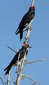
Jays, Magpies, Crows & Ravens
Pinyon Jay
Woodhouse's Scrub-Jay
Mexican Jay
Stellar's Jay
Chihuahan Raven
Common Raven
Martins & Swallows
Northern Rough-winged Swallow
Violet-green Swallow
Barn Swallow
Cliff Swallow
Tree Swallow |
|
Tits, Chickadees, & Titmice
Mountain Chickadee
Bridled Titmouse
Juniper Titmouse
Penduline-Tits & Long-tailed Tits
Bushtit
Nuthatches
White-breasted Nuthatch
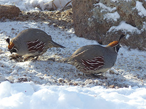
Gambel's Quail
Wrens
Rock Wren
Cactus Wren
Canyon Wren
House Wren
Bewick's Wren
Gnatcatchers
Blue-gray Gnatcatcher
Dippers
American Dipper
Kinglets
Ruby-crowned Kinglet
Thrushes
Eastern Bluebird
Western Bluebird
Hermit Thrush
American Robin
Mountain Bluebird
Townsend's Solitaire
Catbirds, Mockingbirds, & Thrashers
Curve-billed Thrasher
Northern Mockingbird
Starlings & Mynas
European Starling
Silky-flycatchers
Phainopepla
Olive Warbler
Olive Warbler
Finches, Euphonias, & Allies
House Finch
Cassin's Finch
Pine Siskin
Lesser Goldfinch
American Goldfinch
New World Sparrows
Cassin's Sparrow
Chipping Sparrow
Black-chinned Sparrow
Black-throated Sparrow
Lark Sparrow
Dark-eyed Junco
White-crowned Sparrow
White-throated Sparrow
Song Sparrow
Lincoln's Sparrow
Rufous-crowned Sparrow
Canyon Towhee
Green-tailed Towhee
Spotted Towhee
Yellow-breasted Chat
Yellow-breasted Chat
Blackbirds, Meadowlarks & Orioles
Hooded Oriole
Scott's Oriole
Bullock's Oriole
Brown-headed Cowbird
Brewer's Blackbird
Red-winged Blackbird
Great Tailed Grackle
Western Meadowlark
Wood-Warblers
Orange-crowned Warbler
Lucy's Warbler
Virginia's Warbler
MacGillivray's Warbler
Yellow Warbler
Nashville Warbler
Yellow-rumped Warbler
Grace's Warbler
Wilson's Warbler
Red-faced Warbler
Lazuli Buntings
Cardinals, Grosbeaks, & Allies
Summer Tanager
Western Tanager
Scarlet Tanager
Northern Cardinal
Black-headed Grosbeak
Blue Grosbeak
Lazuli Bunting
Indigo Bunting
|
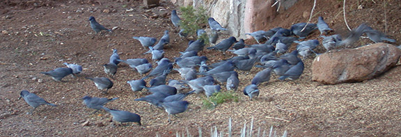
Pinyon Jays
Also Visit:
The Nature Conservancy's Gila River Riparian Preserve
Southwestern New Mexico Audubon Society
New Mexico Ornithological Society
Call us now to book your stay
at our unique and peaceful Nature retreat,
and start planning your New Mexico birding adventure. |